Bailey Avenue Corridor
Making Bailey Ave healthy, equitable, sustainable, and imageable
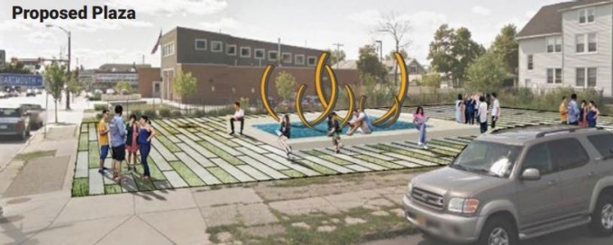

Image source: ARC 656 | Understanding Good Urban Form
Bailey Avenue is the central corridor of the University Heights neighborhood. Bailey offers a tightly knit urban fabric that bustles with pedestrian activity and frequent vehicle traffic. But vacant lots and storefronts, sparse amenities for pedestrians, and limited green space present many opportunities to reimagine the corridor and maximize its potential. Through a comprehensive on-the-ground visual inspection and analysis of the urban design of the corridor, three separate teams of students each made targeted proposals for the redesign of the streetscape and vacant lots along Bailey Avenue. These proposals are intended to inform current and future efforts to enhance Bailey Avenue and University Heights.
Mapping Urban Form | Key Findings
Students looked at Bailey Avenue in context of the region, city and neighborhood to map the paths, edges, districts, nodes and landmarks that form one’s mental map of the neighborhood. Part of NYS route 62, a prime north-south connector for the entire Buffalo Niagara region, Bailey Avenue is a central pathway for pedestrians and vehicles in the University Heights neighborhood. At intersections with other major pathways, like Main Street, Bailey forms key nodes for pedestrians. Nearby paths create edges for the urban form, either by restricting pedestrian activity, like the Kensington Expressway, or by limiting vehicle traffic, like the multi-use recreational path in Linear Park. Defining landmarks, like churches, area parks, and the University Campus, help pedestrians navigate the neighborhood and delineate nearby commercial and residential districts.
Analyzing the Visual and Spatial Structure | Key Findings
Students found that simple interventions, like cleaning up refuse and providing trash and recycling amenities along sidewalks, could greatly improve the streetscape. Other steps, like improved landscaping along sidewalks, tree plantings, benches, or public art, could also enhance aesthetics along the corridor. Clearly delineated crosswalks, traffic lanes, and parking spots could calm traffic and significantly improve safety for both pedestrians and vehicles. Promoting cohesive design standards, including transparent storefronts and landscaped parking lots, would make the corridor more welcoming to pedestrians. Fortunately, the neighborhood has many assets, like a community garden, to create a more welcoming environment for neighborhood residents and visitors.
Envisioning Opportunities
After performing the visual-spatial analysis, students applied their findings to design targeted proposals to enhance the streetscape and key sites along the corridor. Taken together, these proposals present a sound vision for the corridor, grounded by a thorough assessment.
Without a cohesive vision, piecemeal proposals can create a chaotic urban form of dissimilar buildings, untapped vacant sites and streets clogged with traffic. These visions for Bailey Avenue are sound, but would require community involvement and extensive public input to bring to reality. This process was excluded due to the constraints in time and scope of the semester-long seminar. The student work offers a constructive starting point to begin a community conversation on improving the urban form of Bailey Avenue that can spur additional enhancements across the neighborhood.
Fall 2017 | ARC 656 | Understanding Good Urban Form
Instructor: Hiro Hata
Students:
Matthew Abbott
Lauren Darcy
Connor Hannan
Zhuoshu He
Felicia Kilbin
Sylvester Mallardi
Jeff Rehler
Kai Sun
Doug Wessells