Neighborhood overview
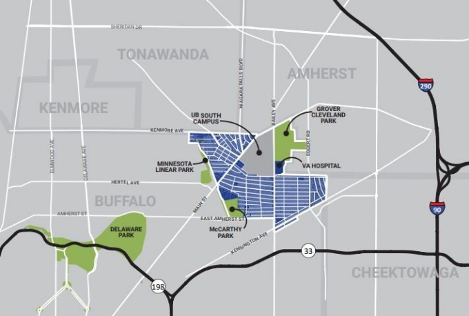

University Heights geography. Map by UBRI
In summer 2017, the UB Regional Institute (UBRI), a research center in the School of Architecture and Planning, preformed preliminary research on the University Heights to answer some basic questions that inform future student explorations. This research examined demographic, economic, and geographic data about the neighborhood, and reviewed past plans related to University Heights.
Where is the University Heights?
The University Heights is a neighborhood in the northeast corner of Buffalo, NY, the largest city in Erie County and the Buffalo Niagara region. Originally planned as a streetcar suburb of the City, the University Heights neighborhood borders the towns of Tonawanda, Amherst, and Cheektowaga.
Today, the neighborhood serves as the northern terminus of the City's Metro Rail system as well as the home to the University at Buffalo's South Campus, whose presence creates a unique cultural and demographic dynamic. Most of the neighborhood consists of single family and multifamily residential homes. Two major commercial corridors, Main Street and Bailey Avenue, differentiate distinct areas of the neighborhood; a third commercial corridor, Kenmore Avenue, runs along the northern border of the neighborhood.
Looking at plans for insights on the community
Plans create a guide for the future of a place and offer insights into the needs, desires, values, and vision of a community. A review of 29 plans that have influenced the University Heights neighborhood reveals seven predominant themes important to planning and design work in the community. The plans’ objectives, recommendations and visions for the future offer insights into some of the challenges, opportunities, and aspirations that the neighborhood identified in the past.
The seven main planning themes are:
- Revitalizing neighborhood commercial corridors
- Transit oriented development
- Leveraging the University
- Promoting equity and opportunity
- An engaged and collaborative community
- Quality of life improvements
- Preserving neighborhood character
Looking to the data to understand the community
Current conditions of the University Heights show a resilient neighborhood that is shaped by both challenges and opportunities. Below is a brief overview of findings from data on neighborhood demographics, economic trends, land use patterns, real estate, crime, and more. Combined with the themes taken from past and ongoing planning work, the knowledge of existing conditions in the University Heights can help guide community decisions, investments, and future student-based planning and design studies in the neighborhood. To explore each finding in more detail, click the link below to download the full report section as a PDF.
Demographics
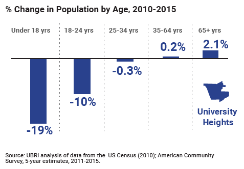
- The neighborhood is home to many young, college-age adults
- The neighborhood’s population is shrinking.
- The racial and ethnic composition of the neighborhood is changing.
- Many children and young adults in the neighborhood live in poverty.
Jobs and Workforce
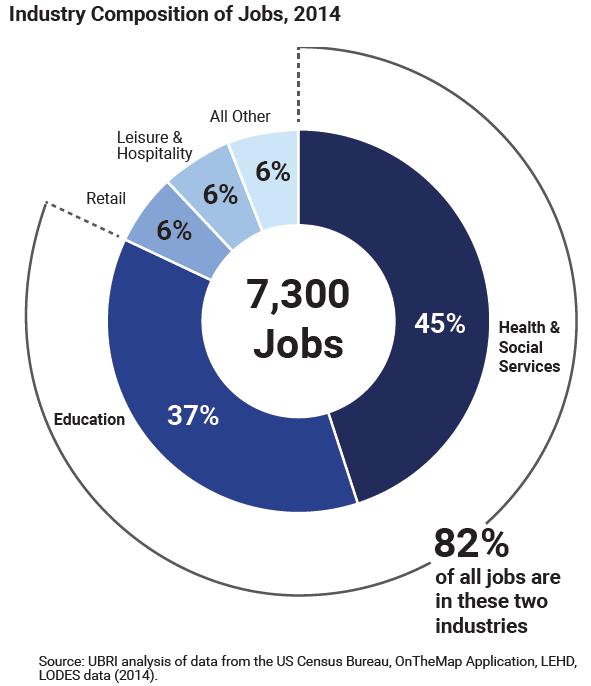
- Jobs are concentrated in five major industries.
- Most employed residents work outside the neighborhood.
- Educational attainment of adults lags behind the City.
- Labor force participation rates are lower than the City.
- More young people are out of work and school than in the rest of the City.
- Household incomes are slightly higher than across the City but below the region
Built Environment

- More than half of land is devoted to residential uses.
- Historic places contribute to the neighborhood’s character.
- The neighborhood has a variety of community and recreational assets.
Real Estate Market
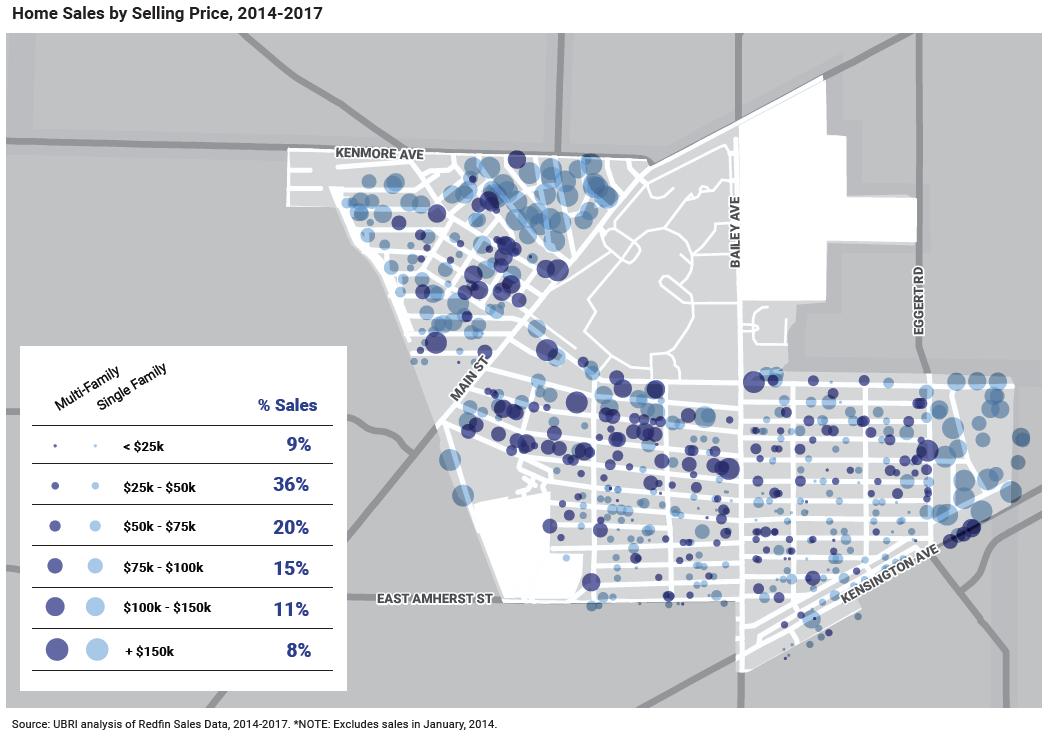
- There have been many home sales in recent years.
- Commercial vacancy rates are more than double residential vacancy rates.
Transportation Options
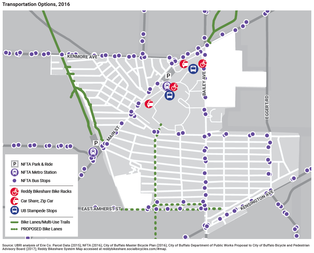
- The neighborhood is connected via diverse transportation modes.
- More residents take public transit or walk to work than across the City and region.
- Compared to the City, public transit is more of a choice than necessity for residents.
Crime and Safety
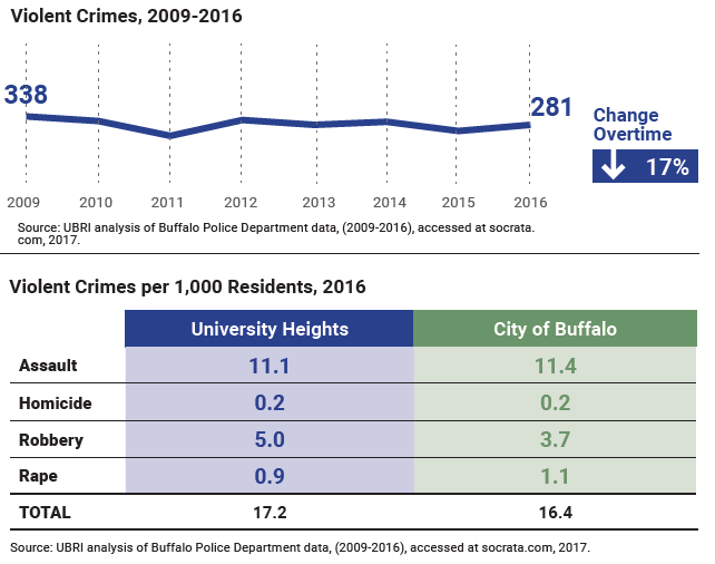
- Violent crimes are less prevalent than across the City.
- Property crimes in the neighborhood are on the decline.