Uncovering cultural landscapes

Students walk the 15-mile Buffalo Belt Line as part of a preservation planning studio that explored the former passenger rail line’s significance as a cultural landscape.
Urban planning students have assumed an almost investigative role as they explore two of Buffalo’s most historically significant — and hidden — landscapes: the Buffalo Belt Line, a former passenger rail line that loops the city almost unnoticed; and the Scajaquada Creek, a largely buried 13-mile stream whose shores trace the evolution of Buffalo.
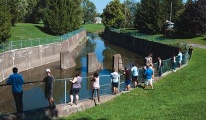

Students in Kerry Traynor’s fall 2016 studio traversed almost the entire 13-mile Scajaquada Creek shoreline to collect field data and consider opportunities for daylighting.
The studies are the most recent in a series of preservation planning studios that seek to uncover the historic and cultural contexts of buildings and landscapes throughout Buffalo. Led by Kerry Traynor, a clinical assistant professor and practicing preservation planner, the studios have also examined historic neighborhoods in South Buffalo, Buffalo’s grain elevator district and the Paul Rudolph- designed Shoreline Apartments. The resulting studies have secured National Historic Register designations (e.g., for the grain elevators) and provided developers and city leaders with critical historic data and context-sensitive design guidelines. The staple of the Master of Urban Planning curriculum is also core to the school’s new historic preservation specialization and certificate programs.
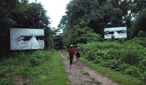

Photo of joggers on path courtesy of the b-linebroker.com
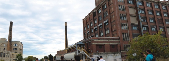
The fall 2015 study of Buffalo’s Belt Line focused on the legacy of this 19th century rail loop, which slices through neighborhoods and former industrial corridors and over city streets via truss and beam bridges. Though ‘hidden in plain sight,’ Traynor says the Belt Line is arguably as important as Joseph Ellicott’s radial street plan and the Olmsted park and parkway system in shaping the city’s development, particularly its neighborhoods as industry spread outward via the passenger and freight line. Buffalo planners are now focusing on the industrial building stock along the line as the city’s next frontier for walkable, mixed-use development.
Traynor’s students’ final plan included a comprehensive mapping of the loop, the identification of cultural zones and the development of land use and urban design proposals, from signage systems to linear parks, to forge stronger physical and cultural connections to the landscape.
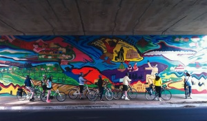

Among these was Robert Sozanski’s (MUP ’16) proposal for public art installations along the entirety of the corridor. Including didactic murals, site-specific sculpture and interpretive urban design, the series would tell a story of the Belt Line and create new points of engagement for the public.
Students spent fall 2016 studying Scajaquada Creek, a 13-mile waterway that begins just northeast of the city and winds its way into an underground culvert before emerging in Forest Lawn Cemetery, snaking under the Scajacuada Expressway and emptying into the Niagara River.
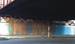

Robert Sozanski, who is forming a nonprofit to develop his plan, illustrates his concept: An underpass near the Northland industrial corridor celebrates African-American contributions to the post-war industrial boom on Buffalo’s East Side
Traynor says the history of the city can be traced by the evolution of the creek, from its modification during construction of the Erie Canal to its burial in the 1920s and alteration to make way for expressways in the 1950s. The creek is also battle field land — the Battle of Scajaquada Creek Bridge was fought here during the War of 1812. Focusing on the underground portion of the creek, students studied the history of change at the creek and developed a master plan and design guidelines for re-establishing or daylighting portions of the creek and preserving the creek as a natural and cultural resource.